What is Natura 2000?
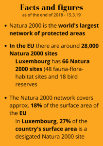
Natura 2000 is a European network of protected areas for threatened or particularly typical natural habitats and species. The aim is to protect plants, animals and habitats in their natural areas of distribution all over Europe. The network therefore makes an important contribution to protecting biodiversity in the EU.
The Natura 2000 network is made up of areas protected under the Habitats Directive and the Birds Directive.
The Habitats Directive states that special protected areas must be designated for a total of 231 habitat types and around 1000 species across the whole EU. Of those, 28 habitats and 24 species are relevant to Luxembourg.
Under the Birds Directive, special protected areas must be designated for 193 species and for other regularly appearing migratory birds. This applies to a total of 69 bird species in Luxembourg.
Farming is still possible in Natura 2000 sites, provided this does not have a significantly detrimental effect on the habitats or species (ban on deterioration). In some cases, appropriate farming is explicitly desirable, or even essential, in order to preserve habitats and species. It is true that only as a result of human management have many traditional cultural landscapes in Europe become the valuable habitats that we need to protect today (e. g. heathland, coppiced and mixed coppiced and standard forest areas…). Natura 2000 therefore sees people and their activities as an integral part of this European network of protected areas.
Further information and a comprehensive set of FAQs can be found at: https://ec.europa.eu/environment/nature/natura2000/index_en.htm
What is the difference between a Natura 2000 site and a nature reserve?
- Natura 2000 sites have been designated specifically to protect core areas for a sub-set of species or habitat types listed in the Habitats and Birds Directives. They are deemed to be species or habitats of European importance, because they are endangered, vulnerable, rare, endemic, or present outstanding examples of typical characteristics of one or more of Europe’s nine biogeographical regions. In total, there are around 2,000 species and 230 habitat types for which core sites need to be designated as Natura 2000 sites.
Nature reserves, national parks or other nationally or regionally protected sites are, on the other hand, established exclusively under national or regional law, which can vary from country to country. Sites may be designated for a range of different purposes and may also concern species/habitats other than those targeted by the Natura 2000 network.
They do not have the same status as Natura 2000 sites. Nevertheless, it may be that some nationally or regionally protected sites are also designated as Natura 2000 sites because they are important areas for species and habitats of EU importance as well. In such cases, the provisions of the EU directives apply, unless stricter rules are in place under national law. (Source: European Union 1995-2022 https://ec.europa.eu/environment/nature/natura2000/faq_en.htm#1-0)
How are Natura 2000 sites selected?
- Natura 2000 sites are selected with the aim of ensuring the long-term survival of species and habitats protected under the Birds and the Habitats Directive. The choice of sites is based on scientific criteria.
In compliance with the Birds Directive, EU Member States are required to designate the ‘most suitable territories’, both in number and surface area, to protect bird species listed in Annex I of the Directive as well as migratory species.
In compliance with the Habitats Directive, Member States have to designate the sites required to ensure that the natural habitat types listed in Annex I and the habitats of the species listed in its Annex II are maintained or, where appropriate, restored to a favourable conservation status in their natural range.
The sites are selected and proposed by the Member States. The European Environment Agency (EEA) then assists the European Commission in analysing sites proposals and in the evaluation of the contribution of the proposed sites to the conservation status of each habitat type and species at the biogeographical level. Once the sites proposed under the Habitats Directive are considered sufficient, the lists of sites are adopted by the Commission and the Member States must designate them as Special Areas of Conservation (SACs) as soon as possible and within six years at most. (Source: European Union 1995-2022 https://ec.europa.eu/environment/nature/natura2000/faq_en.htm#1-0)
What does the COPIL Natura 2000 Mëllerdall do?
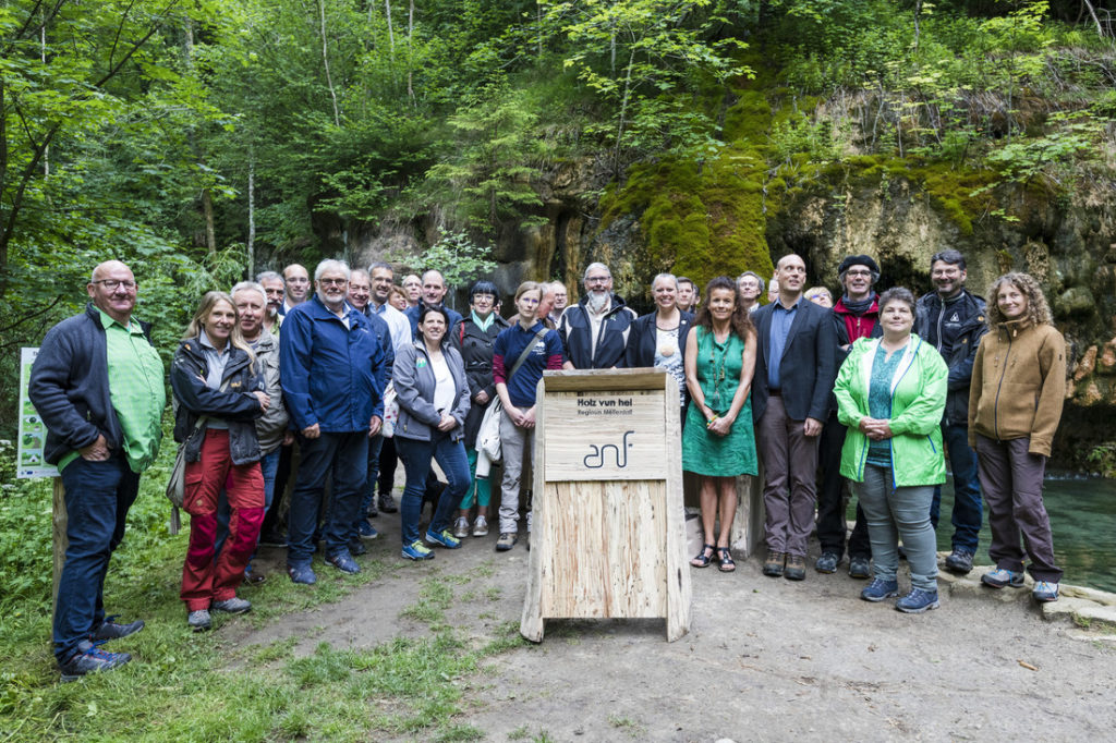
In order to encourage and support the implementation of the management plans for Natura 2000 sites, on 6 June 2019 a steering committee (COmité de PILotage), COPIL for short, was set up for the Nature & Geopark Mëllerdall, also including the Aerenzdallgemeng (municipality of the Vallée de l’Ernz) and the town of Reisdorf. Another intended purpose of the steering committee is to get local stakeholders more involved. In this, the “animateur”/coordinator plays an especially important role, serving as a central point of contact for everything to do with Natura 2000. Their other responsibilities include initiating, coordinating and supporting specific Natura 2000 projects, doing PR work and raising awareness around Natura 2000. On 1 July 2019, the animateur/coordinator appointed to the steering committee for Natura 2000 Mëllerdall began her work at the administrative headquarters of the Natur- & Geopark Mëllerdall.
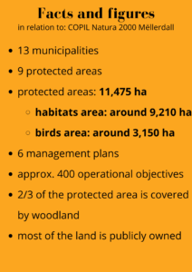
In addition to the representatives of the 13 member municipalities, the COPIL Natura 2000 Mëllerdall consists of actors from the following areas: agriculture, forestry, hunting, fishing, water management, nature conservation, tourism, rural development and transport infrastructure. A list of the COPIL members can be found here.
The office that supports the work of the animateur/coordinator and implements the decisions made by the steering committee is made up of the following members: Jean-Pierre Arend (ANF), Claude Petit (Nature & Geopark Mëllerdall), Stéphanie Weydert (elected representative of the municipalities), Ronnie Schmit (AGE), Yves Mersch (ASTA), Linda Salentin (Tourist Office ORT MPSL).
The chairman of the steering committee is Jean-Pierre Arend (ANF).
You can find a brief description of the conservation areas, of the main conservation objectives and a small photo slide-show here.
You can find more information here.
Is my land in a Natura 2000 site?
- By visiting the Geoportail website, you can see whether your land is located in a Natura 2000 site https://map.geoportail.lu/theme/emwelt?lang=de&version=3&zoom=16&X=697681&Y=6413623&rotation=0&layers=533-540&opacities=0.5-0.5&bgLayer=streets_jpeg
The bird reserves are shown in yellow-green, the FFH (here referred to as “Natura 2000 Habitats”) are in light green. Using “My layers” you can adjust the opacity (transparency) of the two layers. Now scroll to your land.
What does it mean if my land is located in a Natura 2000 site?
Fundamentally, there is a prohibition on deterioration of the habitat types and species and their habitats for which the respective site was designated. This means that the Member State is obligated to the EU to adopt suitable measures in this regard. Where there is a risk that habitats and species found in the site could be impaired due to external influences, the Member State is obliged to determine corresponding measures, including outside the Natura 2000 site if necessary.
Management plans have been developed for each Natura 2000 site, defining various measures aimed at preserving and improving the habitat types and species and their habitats.
If my land is in a Natura 2000 area or is suitable for implementing the measures defined in the respective management plan, I can benefit from higher subsidies, for example. Participation in implementing these measures is voluntary.
Pursuant to the CAP, the following prohibitions apply within Natura 2000 sites (https://agriculture.public.lu/dam-assets/publications/ma/dossier/pac-swot/reform-2023-2027-informationsversammlungen-juni-2022.pdf):
- Use of rodenticides without prior permission
- Breaking up sensitive permanent pasture (= permanent pasture from biotope mapping A+B areas, permanent pasture in HQ>100 flood zones, pasture mapping C areas)
- Harrowing permanent pasture after 30 April
- Reseeding and overseeding of C-biotope areas
What measures are defined in the management plans for the Natura 2000 sites?
The areas are subdivided into various zones in the management plans:
- Alluvial plain and wet grasslands / Open waters and wet environments
- Turf, calcareous grassland and wooded areas / Mesophile grasslands
- Open environment
- Forests / Forests and rocks / Cliffs, rocks and screes
- Various hot-spots (great crested newt, heath, calcareous grassland, quarries)
Objectives to be achieved in the short to medium term and long term are listed per zone. Implementation of the measures is on a voluntary basis and generally qualifies for a subsidy.
The management plan for the FFH site Vallée de l’Ernz noire / Beaufort / Berdorf (LU0001011) can be found here.
The management plan for the FFH site Vallée de l’Ernz blanche (LU0001015) can be found here.
The management plan for the FFH site Herborn – Bois de Herborn / Echternach – Haard (LU0001016) can be found here.
The management plan for the FFH site Vallée de la Sûre inférieure (LU0001017) can be found here.
The management plan for the FFH site Pelouses calcaires de la région de Junglinster (LU0001020) can be found here.
The management plan for the bird reserve Vallée de l’Ernz blanche de Bourglinster à Fischbach (LU0002005) can be found here.
The management plan for the bird reserve Région de Junglinster (LU0002015) can be found here.
The management plan for the bird reserve Région de Mompach, Manternach, Bech et Osweiler (LU0002016) can be found here.
The management plan for the bird reserve Vallée de l’Our d’Ouren à Wallendorf-Pont (LU0001002) can be found here.
If you want to be involved in implementing the plans or have questions about them, please get in touch with the Natura 2000 Coordinator.
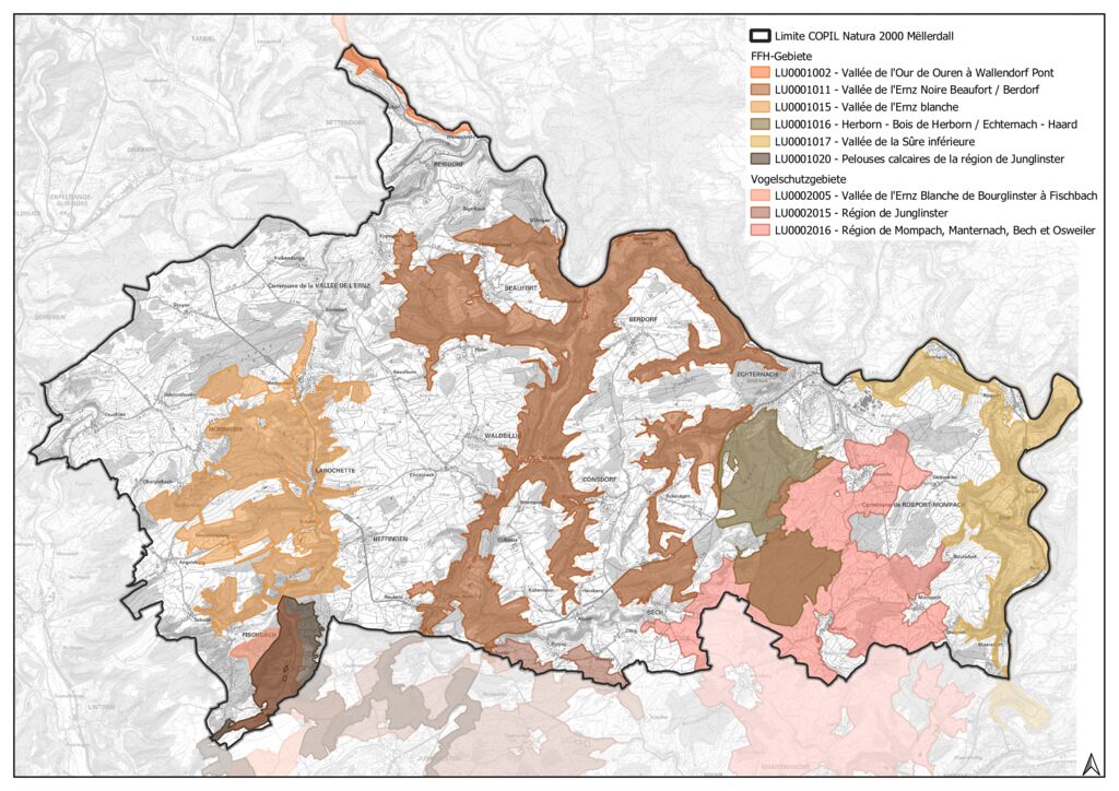
LU0001011: Valley of the Black Ernz / Beaufort / Berdorf
Area: 4195.19 ha (of which COPIL Natura 2000 Mëllerdall is responsible for about 4152 ha)
Brief description (cf. SDF end 2018-15/03/2019):
- The valley of the Black Ernz and its tributaries, cut deep into the sandstone in the heart of the Müllerthal.
- The area is predominantly wooded (around 80%, consisting mainly of Luzulo-Fagetum and Asperulo-Fagetum beech forest). The Elteschmuer here is almost the only example of bog woodland in Luxembourg.
- Typical of the Müllerthal is the high proportion of rocky habitats and caves, so the protected area is also very important for its many rare ferns (incl. the Killarney fern, Trichomanes speciosum) and mosses and also for rock breeding birds such as eagle owls, and for various species of bat that find places to overwinter here.
- Agricultural land use (mainly in the form of permanent pasture) is confined to the flatter parts of the protected area, where there are also still many meadow orchards.
The main targets for protection (under the ban on deterioration) in this area are the following habitats and species (see also RGD 6.11.2009):
- the water quality of the Black Ernz, the Aesbaach, the Lauterbornerbaach and their tributaries,
- various freshwater habitats,
- the population of certain aquatic species such as the brook lamprey and the great crested newt,
- various kinds of woodland such as riparian forest,
- rocky habitats such as limestone or silicate rock with rock cleft vegetation, and caves,
- various kinds of grassland and heathland vegetation (including chalk heath),
- various kinds of moorland habitats, including petrifying springs with tufa formation,
- the population of certain bat species, including Bechstein’s bat,
- Dicranum viride moss and the Killarney fern
LU0001015: Valley of the White Ernz
Area: 2013.82 ha (of which COPIL Natura 2000 Mëllerdall is responsible for 2013.82 ha)
Brief description (see also SDF end 2018-15/03/2019):
- The valley of the White Ernz and the surrounding wooded area between Ernzen and Ermsdorf.
- The area is predominantly wooded (78%, primarily Luzulo-Fagetum and Asperulo-Fagetum beech forest), plus three of the country’s four different kinds of riparian forest occur here.
- The few areas of agricultural land that lie within the protected area are mostly farmed as permanent pasture.
- More than 20% of all Luxembourg’s European dry heath habitat is found here.
- Partly thanks to the high proportion of rocky habitats and caves, the area also includes some interesting sites for many rare ferns and mosses.
The main targets for protection (under the ban on deterioration) in this area are the following habitats and species (see also RGD 6.11.2009):
- the water quality of the White Ernz and its tributaries,
- riparian forest and certain kinds of beech forest,
- various rocky habitats and caves,
- various kinds of grassland and heathland vegetation (including chalk heath),
- the population of the great crested newt and the greater mouse-eared bat
LU0001016: Herborn – Herborn Forest / Echternach – Haard
Area: 1178.36 ha (of which COPIL Natura 2000 Mëllerdall is responsible for 1178.36 ha)
Brief description (see also SDF end 2018-15/03/2019):
- The area is predominantly wooded (86%, mainly Luzulo-Fagetum, Asperulo-Fagetum and Melico-Fagetum beech forest): the Herborn and Haard forests.
- The few areas of agricultural land that lie within the protected area are mostly farmed as grazing land, with annual crops and meadow orchards making up only a small part of the agricultural land.
- The area is a hotspot for juniper formations (over 72% of all occurrences in Luxembourg are found here).
- A hotspot for Dicranum viride moss (one of three hotspots in the country).
- The area is also very important for certain bird species (see also EU bird protection areas LU0002005 and LU0002015)
The main targets for protection (under the ban on deterioration) in this area are the following habitats and species (see also RGD 6.11.2009):
- chalk heath and juniper heath,
- various kinds of beech forest (Luzulo-Fagetum & Asperulo-Fagetum beech forest),
- the population of two bat species (greater mouse-eared bat, Geoffroy’s bat),
- the incidence of Dicranum viride moss
LU0001017: Valley of the Lower Sûre
Area: 1526.98 ha (of which COPIL Natura 2000 Mëllerdall is responsible for 1320 ha)
Brief description (see also SDF end 2018-15/03/2019):
- The lower Sûre valley between Echternach and Wasserbillig and adjacent valley sides and upland areas.
- Almost half the protected area is used for agriculture, with rather more than half of that used for arable farming.
- About one third of the area is covered with deciduous forest, mainly various kinds of beech forest such as Asperulo-Fagetum beech forest.
- Other features of interest are the areas of chalk heath, one of the most species-rich kinds of habitat, Tilio-Acerion forests of slopes, screes and ravines and also the rare limestone beech forest.
- In addition to a big colony of greater mouse-eared bat, other bat species are also of interest in this protected area.
The main targets for protection (under the ban on deterioration) in this area are the following habitats and species (see also RGD 6.11.2009):
- the water quality of the lower Sûre and its tributaries (incl. specific freshwater habitat types and aquatic species such as the brook lamprey),
- various rocky habitats,
- various types of grassland vegetation such as the particularly species- and flora-rich chalk heath and lowland hay meadows,
- various kinds of woodland habitat such as riparian forest and forests of slopes, screes and ravines,
- the populations of the greater mouse-eared bat and the Jersey tiger moth
LU0001020: Calcareous grassland in the Junglinster region
Area: 1507.12 ha (of which COPIL Natura 2000 Mëllerdall is responsible for 454 ha)
Brief description (see also SDF end 2018-15/03/2019):
- Hilly landscape between the Gréngewald forest and the Mëllerdall region around Junglinster, Altlinster, Bourglinster, Godbrange, Oberanven and Ernster.
- Rather more than half the protected area is used for agriculture – mostly in the form of grassland, but there are also meadow orchards here.
- Also worth highlighting is the chalk heath (a quarter of Luxembourg’s total) which is particularly rich in endangered animal and plant species – and in places there is an impressively large number of orchids.
- The large areas of wet grassland are mainly in the valley of the White Ernz.
- The wooded areas are also largely confined to the slopes of the Black and White Ernz valleys (Bierger and Weimericht).
- In addition to its importance as a habitat for a colony of greater mouse-eared bats, the area is also very significant for a number of bird species (see also EU bird protection areas LU0002005 and LU0002015).
The main targets for protection (under the ban on deterioration) in this area are the following habitats and species (see also RGD 6.11.2009):
- various types of grassland, including chalk heath,
- juniper heath,
- riparian forest and certain kinds of beech forest,
- the populations of the greater mouse-eared bat and the marsh fritillary
LU0002005: Valley of the White Ernz from Bourglinster to Fischbach
Area: 758.73 ha (of which COPIL Natura 2000 Mëllerdall is responsible for 374 ha)
Brief description (see also SDF end 2018-15/03/2019):
- The area extends along the valley of the White Ernz between Bourglinster and Fischbach.
- Three-quarters of the protected area is used for agriculture – most of it as grassland (including purple moor-grass meadow) which provides a habitat for many (rare) bird species (such as the meadow pipit).
- Of particular interest here are the large areas of wet grassland, some with reed beds and large sedge swamps (providing a habitat for Eurasian reed warblers and common reed buntings, among others).
- The wooded part (of which more than half is deciduous woodland) is mainly confined to the slopes to the north of Junglinster and south of Fischbach; there are also some small sections of riparian forest.
- Along the White Ernz there is evidence of the presence of kingfishers.
- Evidence of breeding red kites, black kites and European honey buzzards, among others, is regularly seen.
- During the migration season, Northern lapwing are seen, sometimes in large numbers and sometimes accompanied by European golden plovers and other wading birds.
The main targets for protection (under the ban on deterioration) in this area are the following habitats and species (see also RGD 30.11.2012):
- the populations of the following bird species: kingfisher, corncrake, red-backed shrike, great grey shrike, black kite, red kite, European honey buzzard,
- and other bird species living on grassland, marshes, large sedge swamps/reed beds and other wetland areas
LU0002015: Junglinster region
Area: 3058.74 ha (of which COPIL Natura 2000 Mëllerdall is responsible for 192 ha)
Brief description (see also SDB end 2018-15/03/2019):
- Hilly landscape between the Gréngewald and the Mëllerdall region.
- The majority of the protected area is used for agriculture – three-quarters of it as grassland, providing a habitat for many (rare) bird species (such as the Eurasian skylark, quail, partridge)
- The well-structured and extensively used agricultural areas (a mosaic of dry grassland and wetland areas) have Luxembourg’s highest population density of great grey shrike and red-backed shrike – and the common linnet and Eurasian wryneck are also found here.
- Most of the wet grassland areas and reed beds are to be found in the valley of the Black Ernz – this is where, in particular, the Eurasian reed warbler, common reed bunting, kingfisher and black stork are to be found.
- Also of particular interest are the species-rich chalk heath (a quarter of Luxembourg’s total), mainly confined to the sunny slopes around the small town of Junglinster.
- Most of the small area of woodland is made up of various kinds of beech forest (incl. Luzulo-Fagetum and Asperulo-Fagetum beech forest) and is home to, among other species, wood warblers, black woodpeckers and other kinds of woodpecker.
- Birds of prey such as the red kite, black kite and hen harrier are also regularly seen in the protected area.
The main targets for protection (under the ban on deterioration) in this area are the following habitats and species (see also RGD 04.01.2016):
- the populations of the following bird species: Eurasian skylark, black stork, hen harrier, red-backed shrike, great grey shrike, black kite, red kite, European honey buzzard, wood warbler, Northern lapwing
- and other bird species living in open landscapes or on grassland, orchards and other structured landscapes or on marshes, large sedge swamps/reed beds and other wetland areas
LU0002016: Region around Mompach, Manternach, Bech and Osweiler
Area: 4962.77 ha (of which COPIL Natura 2000 Mëllerdall is responsible for 2584 ha)
Brief description (see also SDB end 2018-15/03/2019):
- Landscape between Mompach, Manternach, Bech and Osweiler, an area criss-crossed by several waterways.
- Two-thirds of the protected area is used for agriculture (mainly grassland which provides a habitat for many (rare) bird species such as the Eurasian skylark, quail, partridge).
- The well-structured and extensively used agricultural areas (a mosaic of dry grassland and wetland areas, together with a number of valuable meadow orchards) have a high population density of great grey shrike and red-backed shrike – and the common linnet and Eurasian wryneck are also found here.
- Also of particular interest are the species-rich chalk heath and low-nutrient meadows.
- Along the river banks, Eurasian reed warblers, common reed buntings, kingfishers and black storks are found.
- The wooded areas consist mainly of deciduous woodland (87%) – mostly beech forest, home to wood warblers and various species of woodpecker.
- Birds of prey such as the red kite, black kite and hen harrier are also regularly seen in the protected area.
The main targets for protection (under the ban on deterioration) in this area are the following habitats and species (see also RGD 04.01.2016):
- the populations of the following bird species: Eurasian skylark, black stork, hen harrier, red-backed shrike, great grey shrike, black kite, red kite, European honey buzzard, wood warbler, Northern lapwing
- and other bird species living in open landscapes or on grassland, orchards and other structured landscapes or on marshes, large sedge swamps/reed beds and other wetland areas
LU0001002: Valley of the Our from Ouren to Wallendorf-Pont
Area: 5675.92 ha (of which COPIL Natura 2000 Mëllerdall is responsible for 90 ha)
Brief description (see also SDB end 2018-15/03/2019):
- The western side of the Our valley including its tributaries and part of the Ardennes upland plateau from the border between Belgium, Germany and Luxembourg as far as Wallendorf.
- The area is very important for species that need moving water (such as the thick shelled river mussel and freshwater pearl mussel) – this is also the only known site in Luxembourg where the orange-spotted emerald dragonfly is found.
- Almost half the wooded area consists of conifers, while more than half the deciduous woodland and therefore over one-third of the wooded slopes is covered in coppice.
- Also of particular importance are the forests of slopes, screes and ravines and the remnants of riparian forest.
- Approx. 18% of the protected area is used for agriculture – a third of it for arable crops, but in the Our valley there are still a few valuable and species-rich low-nutrient meadows.
- The area is also very important for certain bird species (see also EU bird protection area LU0002003).
The main targets for protection (under the ban on deterioration) in this area are the following habitats and species (see also RGD 6.11.2009):
- the water quality of the Our and its tributaries (incl. a specific type of freshwater habitat and aquatic species such as the thick shelled river mussel, freshwater pearl mussel, otter, brook lamprey, orange-spotted emerald dragonfly),
- various types of species-rich grassland, including Nardus grassland and low-nutrient meadows,
- various kinds of woodland, incl. riparian forest, forests of slopes, screes and ravines,
- rocky habitats such as limestone or silicate rock with rock cleft vegetation,
- the populations of the Jersey tiger moth, greater mouse-eared bat, Geoffroy’s bat
(c) cover photo: Photostudio C. Bosseler
Child projects
Natura 2000 verbindet
Trees, hedges or larger elements such as orchards (lux.: “Bongerten”), which structure and enrich our landscape, have become rare. However, these elements are essential for biodiversity. They are habitats for […]


Judith Boveland
- Tél.: +352 26 87 82 91-38 / +352 621 666 092
- E-mail: judith.boveland@naturpark-mellerdall.lu