The history of the Natur- & Geopark Mëllerdall begins around 245 million years ago, in a sea. Countless particles of sand and others were deposited and solidified into rock. The sea disappeared, and rivers shaped the impressive rocky landscape of the Natur- & Geopark Mëllerdall we see today.
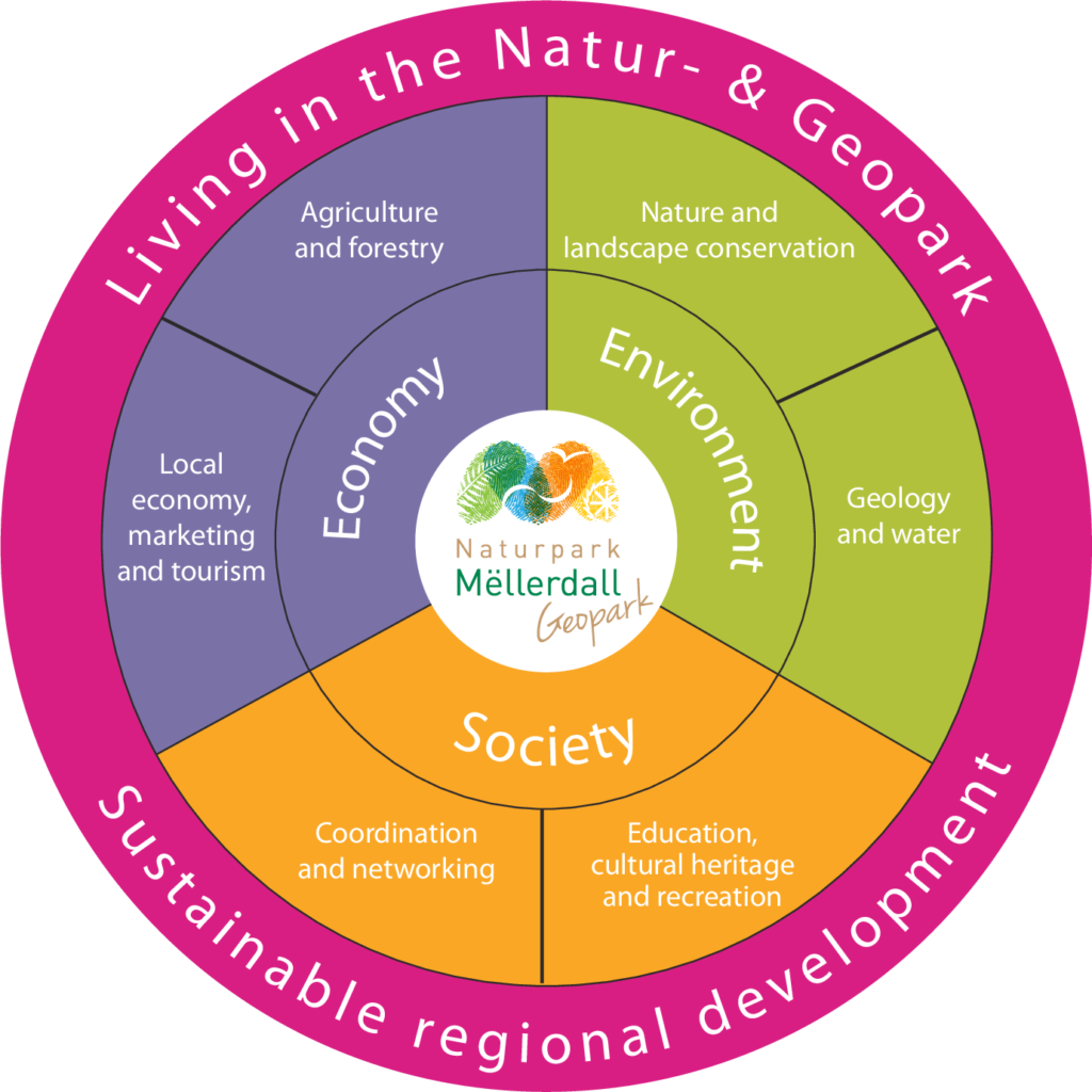
Located on this outstanding geological heritage, a diverse and valuable natural and cultural heritage came into being. The task of the Natur- & Geopark Mëllerdall is to preserve this heritage and to develop our region sustainably. At all times, the central focus of our actions is the people.
We want to achieve these aims by concentrating our work on three areas:
Discover the region | Support services | Projects
Under the heading of “Discover the region”, we provide information about our region, we raise awareness of our heritage and of sustainable development, and we offer a wide range of activities.
Our staff are available for residents, businesses and communities of the Natur- & Geopark Mëllerdall to provide various free support services.
Practical initiatives are being implemented through various projects: for instance, an energy cooperative has been set up, enabling the local population to collaborate in the sustainable development of the region, and every year several hundred fruit trees are planted in order to preserve our meadow orchards.
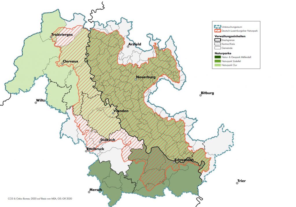
The numerous mills along its rivers and streams gave its name to the Natur- & Geopark Mëllerdall (“Valley of the millers”). Imposing rocks, deep valleys and extensive plateaus: the Luxembourg sandstone characterizes the region and has made it known beyond its borders. Here in the east of the Grand Duchy, on the border with Germany, 11 municipalities with a total area of 256 km2 and around 25,800 inhabitants joined to form a Nature and Geopark.
The Natur- & Geopark Mëllerdall – a special purpose association of member municipalities and the state
The Natur- & Geopark Mëllerdall is a special purpose association (“syndicat mixte” / mixed administration union) of the municipalities and the state. The list of members and the composition of the board (committee) can be found here. It was established by the Grand Ducal Regulation of March 17th, 2016. The Grand Ducal Decree of June 10th, 2016 governs the management of the Nature & Geopark for a term of 10 years.
What is a Nature & Geopark?
Nature and Geoparks support the sustainable development of a region – this means that social, ecological and economic issues are taken into account equally. This can only be implemented together with the people who live and work in the region, or who visit our region. People are at the centre of the Nature & Geopark idea. A Nature & Geopark is not a protected area. Nor should they be confused with national parks, where nature conservation takes priority.
In a Geopark the particular regional geology features are also highlighted.
The geology shows how landscapes are created, which rocks and raw materials occur in the underground and how geology and soils influence land use.
Why a Nature & Geopark?
Only regions that have a unique natural and cultural heritage can become a Nature & Geopark. Nature & Geoparks promote a sustainable use of this heritage while at the same time supporting economic and socio-cultural development.
In addition, the Nature & Geopark strengthens regional cooperation and offers an ideal platform for international projects. Due to the positive association, the labels “Nature Park” and “Geopark” are an image boost for the region.
Additional advantages are own staff, who through their expertise and services, assist the region and improve the recreational and leisure offer for locals and tourists.
The advisory commission (commission consultative)
The Nature Park Law of 1993 provides for the establishment of an advisory commission. It provides advice to the board and issues an opinion on the annual budget. The advisory commission includes representatives of the local population as well as various local and regional interest groups and associations. Its composition, organization and activities are set out in the Grand Ducal Regulation of March 17th, 2016. The following PDF lists current and alternate members.
Germano-Luxembourg Nature Park
On 17 April 1964, the Germano-Luxembourg Nature Park was founded as the first cross-border Nature Park in the whole of Western Europe. In a state treaty between the state of Rhineland-Palatinate and the Grand Duchy of Luxembourg, an area of 789 km2 on both sides of the rivers Our and Sauer was combined as the Germano-Luxembourg Nature Park. The institutional body is the Association Germano-Luxembourg Nature Park with its headquarters in Irrel and representatives from the various regions and countries.
In 1973, this international Nature Park became the 13th region to receive the Council of Europe’s European Diploma for Protected Areas. This was extended in 2020 until 2028.
History
The “Natur- & Geopark Mëllerdall” was established on March 26th, 2016 (publication date of the Grand Ducal Regulation of March 17th, 2016 plus 3 days). Since then there have been 3 nature parks in Luxembourg – the two nature parks Öewersauer and Our are located in the north of the country. The Nature Park Act of August 10th, 1993 regulates, among other things, the establishment and management of natural parks in Luxembourg.
- 1993: First official mention of a nature park Müllerthal in the “Programme Directeur” of the national Spatial Planning
- 2006 – 2008: LEADER project: “Man and stone – experience geology”
- 2006, Spring: Establishment of the working group “Naturpark Müllerthal” by RIM non-profit organisation at the suggestion of the executive board of the LAG LEADER + Müllerthal
- 2009, Autumn: Foundation of the “Syndicat Mullerthal”, the administration union of municipalities responsible for the establishment of the nature park
- 2011 – 2014: LEADER project: “Geopark Müllerthal – A region with special features”
- 2011 – 2014: LEADER project: “Alb and Thal … Steinreich! Geology in the Brenz region and Müllerthal – two regions and their geological peculiarities “
- 2012, Spring: Presentation of the “Etude préparatoire” (“preliminary study”)
- 2013, March: Start of the “Etude détaillée” (“master plan”)
- 2014, Summer: Completion of the “Etude détaillée”
- 2014, November: Presentation of the “Etude détaillée” :
The finished “Etude Détaillée” was presented to the public in three information events (Echternach, Müllerthal and Heffingen) in November 2014.
The entire document and a summary in French are available online here. Information on the development process or the results of the individual working groups can also be found in this document - 2016, March: Establishment of the nature park
- 2016, June: Establishment of the supporting structure of the nature park
- 2016, June: Establishment ceremony of the nature park
- 2016, Autumn: The nature park becomes a “nature- & geopark”
- 2017: July: Meeting for the establishment of the advisory commission (commission consultative)
- 2017 – 2019: First candidacy for the UNESCO Global Geoparks program
- 2019: application to change the official name to “Natur- & Geopark Mëllerdall”
- 2019-2020: Preparation of the new candidacy for the UNESCO Global Geoparks program
- 2020, November: Submission of the application dossier for the UNESCO Global Geoparks Program
- 2021, October: On-site evaluation by 2 UNESCO experts
- 2021: Start of the admission procedure for the municipality of Reisdorf to join the Natur- & Geopark Mëllerdall
- 2022, April: Inclusion of Natur- & Geopark Mëllerdall in the international network of UNESCO Global Geoparks